 DAY
01:
We
drive from Kathmandu to Trishuli via Kakani, an excellent spot to
view Mountain range, for about 4 hours and from Trishuli it's a
steady drive of about another 4 hours up to Dunche (1970m) and
it's 110 km in total. Dunche is our campsite for today. From here
we have excellent views of the high peaks. The most notable are
Gheng (6581m), and Langtang Lirung (7246m) to the north and Ganesh
peak (7460m) to the west.
DAY
02:
Crossing the Trishuli river (1680 m) as it drains away from the
Gosainkund Lakes, we climb steeply through beautiful Chir and Blue
pine forest. This is usually an excellent day for wildlife and
birds. By the time we reach Syabur (2130m), out camp site, the
views the Langtang valley are magnificent and more and more of the
snow peaks of Tibet became visible.
DAY
03:
We
descend to the Langtang river (1890m), cross and head upriver
through an impressive gorge. For the rest of the day, there is
almost no human habitation but the forests of rhododendron and
prickly leafed oak, alive with birdlife. We camp at Gomna (1804M),
just as the valley starts to widen again.
DAY
04:
The
valley is now the typical glacier-worn-shaped valley, in contrast
to the steep water-worn V-shaped valley, we passed through
earlier. Keep our eyes open for the Himalayan Thar, a large
mountain goat often seen on the higher slopes. Views of the valley
and its soaring peaks are vary impressive. We lunch near the
Tibetan village of Langtang. After Lunch, we continue through the
Yak pastures under the great snow peaks to Kyangin Gompa (3800m)
and camp.
DAY
05:
Today
is a rest and exploration day. From out campsite, the views of
Langtang Lirung (7246m), Langtang Ri (7239m), Lonpo Gang (7100m),
and Dorji Lakpa (6989m) are magnificent. This is a day to rest and
relax or if you wish, there are several worthwhile excursion up to
the glaciers. A 2 hours climb to Yala, a small cheese factory
provides spectacular views. The valley is in the midst of
exceptionally rugged and beautiful mountain ranges, ringed with
glaciers, snowfalls and huge moraines.
DAY
06:
We
retrace our steps downhill to Gomna. A very pleasant walk.
DAY
07:
We
descend downhill to cross the Langtang river again. We have plenty
of time to enjoy the large stands of Larch, the flowers and the
valley views. After lunch, we climb steeply ton Syabru and camp.
DAY
08:
A day
climbing through forests of fir and rhododendron. The only signs
of human habitation are the occasional shepherd's huts. At the
points where water is found. We camp near the deserted Sing
Gompa(3254m).
DAY
09:
A
steep rugged trail but adequately compensated for by dramatic
views: to the west-Himal Chuli (7893m), Manaslu (8156m), and
Ganesh peak (7406m). And possibly even the Annapurna ranges.
Towards the north, across the valley is Lngtang Lirung. We pass
the few huts in high yak pastures of Laurebina (3901m), cross a
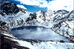
small ridge and have our first views of the Holy Lakes. There are
over a dozen lakes in the Gosainkund Basin, the main three being
Saraswatikund, Bhairavkund and Gosainkund. According to the
legend, Gosainkund was created by Lord Shiva when he pierced a
glacier with his trident to obtain water to quench his thirst
after swallowing some poison. Camp at Gosainkund (4300m).
DAY
10:
We
continue over rugged trails and pass several trains and pass
several other smaller lakes to the Thare Pati Pass (4602m), then
descend along a ridge to the treeline past beautiful waterfalls,
through juniper and rhododendron forest,n we descend to the huts
to Thare Pati. This is a long but very interesting day and we camp
at Thare Pati.
DAY
11:
We
drop steadily all day through fir and rhododendron forests and
then through prickly leafed oak forest. We camp at the Tamang
village of Gul Bhangjyang (2130 m). This ridgewalk provides
excellent views of the mountains and the Helambu valley.
DAY
12:
The
day's walk consists of gentle 'ups & downs' generally following a
ridge to camp just above Chisopani (2194m) with excellent
panoramic views of the Himalaya from Ganesh to Everest.
DAY
13:
We
climb to the small pass at Burlang Bhagjyang (2438m) and take our
last look at the great line of snow peaks of the Himalaya before
descending to the Kathmandu valley and Sundarijal (1457m) from
where we drive back to Kathmandu. DAY
01:
We
drive from Kathmandu to Trishuli via Kakani, an excellent spot to
view Mountain range, for about 4 hours and from Trishuli it's a
steady drive of about another 4 hours up to Dunche (1970m) and
it's 110 km in total. Dunche is our campsite for today. From here
we have excellent views of the high peaks. The most notable are
Gheng (6581m), and Langtang Lirung (7246m) to the north and Ganesh
peak (7460m) to the west.
DAY
02:
Crossing the Trishuli river (1680 m) as it drains away from the
Gosainkund Lakes, we climb steeply through beautiful Chir and Blue
pine forest. This is usually an excellent day for wildlife and
birds. By the time we reach Syabur (2130m), out camp site, the
views the Langtang valley are magnificent and more and more of the
snow peaks of Tibet became visible.
DAY
03:
We
descend to the Langtang river (1890m), cross and head upriver
through an impressive gorge. For the rest of the day, there is
almost no human habitation but the forests of rhododendron and
prickly leafed oak, alive with birdlife. We camp at Gomna (1804M),
just as the valley starts to widen again.
DAY
04:
The
valley is now the typical glacier-worn-shaped valley, in contrast
to the steep water-worn V-shaped valley, we passed through
earlier. Keep our eyes open for the Himalayan Thar, a large
mountain goat often seen on the higher slopes. Views of the valley
and its soaring peaks are vary impressive. We lunch near the
Tibetan village of Langtang. After Lunch, we continue through the
Yak pastures under the great snow peaks to Kyangin Gompa (3800m)
and camp.
DAY
05:
Today
is a rest and exploration day. From out campsite, the views of
Langtang Lirung (7246m), Langtang Ri (7239m), Lonpo Gang (7100m),
and Dorji Lakpa (6989m) are magnificent. This is a day to rest and
relax or if you wish, there are several worthwhile excursion up to
the glaciers. A 2 hours climb to Yala, a small cheese factory
provides spectacular views. The valley is in the midst of
exceptionally rugged and beautiful mountain ranges, ringed with
glaciers, snowfalls and huge moraines.
DAY
06:
We
retrace our steps downhill to Gomna. A very pleasant walk.
DAY
07:
We
descend downhill to cross the Langtang river again. We have plenty
of time to enjoy the large stands of Larch, the flowers and the
valley views. After lunch, we climb steeply ton Syabru and camp.
DAY
08:
A day
climbing through forests of fir and rhododendron. The only signs
of human habitation are the occasional shepherd's huts. At the
points where water is found. We camp near the deserted Sing
Gompa(3254m).
DAY
09:
A
steep rugged trail but adequately compensated for by dramatic
views: to the west-Himal Chuli (7893m), Manaslu (8156m), and
Ganesh peak (7406m). And possibly even the Annapurna ranges.
Towards the north, across the valley is Lngtang Lirung. We pass
the few huts in high yak pastures of Laurebina (3901m), cross a
small ridge and have our first views of the Holy Lakes. There are
over a dozen lakes in the Gosainkund Basin, the main three being
Saraswatikund, Bhairavkund and Gosainkund. According to the
legend, Gosainkund was created by Lord Shiva when he pierced a
glacier with his trident to obtain water to quench his thirst
after swallowing some poison. Camp at Gosainkund (4300m).
DAY
10:
We
continue over rugged trails and pass several trains and pass
several other smaller lakes to the Thare Pati Pass (4602m), then
descend along a ridge to the treeline past beautiful waterfalls,
through juniper and rhododendron forest,n we descend to the huts
to Thare Pati. This is a long but very interesting day and we camp
at Thare Pati.
DAY
11:
We
drop steadily all day through fir and rhododendron forests and
then through prickly leafed oak forest. We camp at the Tamang
village of Gul Bhangjyang (2130 m). This ridgewalk provides
excellent views of the mountains and the Helambu valley.
DAY
12:
The
day's walk consists of gentle 'ups & downs' generally following a
ridge to camp just above Chisopani (2194m) with excellent
panoramic views of the Himalaya from Ganesh to Everest.
DAY
13:
We
climb to the small pass at Burlang Bhagjyang (2438m) and take our
last look at the great line of snow peaks of the Himalaya before
descending to the Kathmandu valley and Sundarijal (1457m) from
where we drive back to Kathmandu.
|