
India
Travel Club
|
|
India
Travel Club |
|
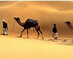
19 Days Round Annapurna Trekking (challenging)Day 01: Kathmandu to Besisahar (823m) approx 6 hrs drives:
The trail continues northwards up the
valley, crossing several suspension bridges and passing several beautiful
waterfalls. Above us tower the peaks of LAMJUNG (6859m). The village
BAHUNDANDA supports the last shops of any size before Jomsom. Today, we descend to the MARSHYANGDI to
access the river level before deciding our route. If water level is low,
we can cross on a makeshift bridge to the east bank. If not, we continue
on the west bank climbing high over a ridge, to rejoin the east bank trail
over a suspension bridge at SANGE. We then climb high again, through
rhododendron and pine forest. The valley is now very deep and steep gorge.
Overnight halt at CHAMJE. We climb steadily all day long TAL, a
small village at the foot of a large waterfall. We are now entering the
MANANG district. After leaving Tal, we cross a large bridge to the village
of DHARAPANI (1943m) where we stop to enjoy a cup of tea. We then climb
through forest to BAGARCHAP the first village on the trek with typical
Tibetan architecture. The trail is now bearing west, MANASLU
forming a splendid backdrop and ANNAPURNA II (7937m) appearing
occasionally to the south. We continue through forests of pine and fir,
resting at the hamlets or CHARKU, THANGJE and KUPARKOT. As we continue on
the trail, views of the ANNAPURNA improve dramatically. We continue crossing the river all day,
passing through the narrow and steep sided gorge nearing the village of
PISANG (3183m). We top a ridge to get our first views of the Manang
valley, a wide N - shaped valley hanging between two lines of snow peaks. Descending to the broad forested valley
floor, we follow the trail through the flat valley, past a small STOL
airstrip, under construction, cross the river once again to BRAGA (3472m)
and en-route visiting BRAGA MONASTERY. This is a village of about 290
houses stacked on top of each other, flat roofs forming verandahs.
We branch away from the ARSHYANGDI river
steadily climbing in to district alpine areas. Keep your eyes open for
Thar and Ghoral mountain sheep. Today we ascending about 3 hours then
descending about 45 minutes to cross the JARSANG river, we climb to a
small grassy valley and overnight halt. Though the crossing of the pass is not
technically difficult, we take it slowly to take into account the
complications of altitude and possible snow. After about 4 hours, we reach
the top (5416m) and enjoy some absolutely stunning high Himalayan scenery.
The entire ANNAPURNA RANGE in the south, the MUKUT and MUSTANG HIMAL to
the west, and the incredibly deep KALI GANDAKI valley and the peaks of
THROUNGTSE (6542m) and CHULU to the north. The trail descends very quickly to the
valley floor over 1538m below. Descend is through a dramatic arid
landscape and continues to JOMSOM (2713m) where you will have lunch. After
the last few days, Jomsom seems almost busy, in fact it is a major village
on the KALI GANDAKI trading route. After lunch continue to MARPHA (2667)
village for overnight halt. We pass through TUKCHE a beautiful
Thakali villages and overnight halt at KALAPANI or LETE. The Thakalis are
the dominant tribe of the valley, related to the Gurung and Magars of the
Southern slopes. As we pass between the Dhauligiri and
Annapurna, a dramatic change in the vegetation occurs today - from dry
desert to pine and conifer forests. Passing through Kalapani and here, the
views of the Annapurnas are breathtaking. We have overnight halt near a
spectacular waterfall at Rukse. As we pass between the DHAULAGIRI and
ANNAPURNA, a dramatic change in the vegetation occurs today-from dry
desert to pine and conifer forests. The views of ANNAPURNAS are
breathtaking. TATOPANI means "Hot water" and it is possible to bathe in
the springs and overnight halt at Tatopani. After crossing the trail ascends
steadily to GOREPANI (2853m) we stop for lunch at SHIKHA. As we climb
steadily all day, we leave behind the terraced fields and enter into thick
rhododendron forest and village of Ghorepani. We halt at the Pass where we
can get the best views of sunset and dawn of the DHAULAGIRI and ANNAPURNA
ranges. This morning walk ascending to pon �
hill for sunrise view from where you can see amazing view of more than 50
mountains. Today's descended is almost as tiring as the day from Muktinath. However, mule trains laden with goods keep us entertained. We cross TIRKHEDHUNGA and BIRETHANTI village and arrive NAYAPUL late in the evening and drive back to POKHARA. Overnight at hotel in Pokhra. |
 After a long drive from Kathmandu,
following wild hairpin ends, we arrive at small village of DUMRE (585m).
Then we drive again through garble road covering around 30 kms slowly
gaining elevation, getting good views of BOUDHA HIMAL (6736m) and
HIMALCHULI (7968m) and to BESISAHAR (823m) our first night halt.
After a long drive from Kathmandu,
following wild hairpin ends, we arrive at small village of DUMRE (585m).
Then we drive again through garble road covering around 30 kms slowly
gaining elevation, getting good views of BOUDHA HIMAL (6736m) and
HIMALCHULI (7968m) and to BESISAHAR (823m) our first night halt. 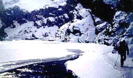 Rest and acclimatization day at Manang
and today we spend the whole day exploring Manang. The village consists of
about 500 flat roofed houses and is picturesquely set amongst spectacular
scenery: ANNAPURNA II, ANNAPURNA III, (7855m), GANGAPURNA (7485m) to the
south: TILICHO (7134m) and the Grand Barrier, to the west; CHULU WEST
(6420m) and CHULU EAST (6558m) to north.
Rest and acclimatization day at Manang
and today we spend the whole day exploring Manang. The village consists of
about 500 flat roofed houses and is picturesquely set amongst spectacular
scenery: ANNAPURNA II, ANNAPURNA III, (7855m), GANGAPURNA (7485m) to the
south: TILICHO (7134m) and the Grand Barrier, to the west; CHULU WEST
(6420m) and CHULU EAST (6558m) to north.